****JavaScript web menu drop down DHTML menu generated by NavStudio. (OpenCube Inc. - http://www.opencube.com)****
|
||||||||||||
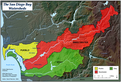
Exceedance MapsExceedance Maps show when a parameter measured (such as heavy metals) exceeds the Maximum Contamination Limit set by the State Water Resources Control Board. On the Exceedance Maps, which are separated by watershed and parameter measured, a red point indicates an exceedance of the water quality standard on the date that parameter was measured. Hovering over a point will give more information on the measurement at that point. For more information on the Water Quality Objectives from which the Exceedance Maps were derived, click here. PuebloSweetwaterOtay
|
||||||||||||