****JavaScript web menu drop down DHTML menu generated by NavStudio. (OpenCube Inc. - http://www.opencube.com)****
|
|
Discourse MapsThe purpose of Discourse Maps is to help facilitate professional discussions about water quality and related issues using both text and maps. Currently, electronic discussions involving multiple participants are led in an unstructured way using e-mail. E-mail postings covering multiple issues over an extended period of time are hard to follow and difficult to synthesize. Discussions related to water quality issues are often related to geographical objects, for example locations of sampling stations. Discourse Maps tool will utilize the geographic nature of water quality-related conversations allowing users to post – both on a map and in textual dialog window, query, view and discuss issues related to water quality in the San Diego Bay watershed. The functionalities will include the capability to search an e-discussion by subject, author or date. User will be able to classify various types of discussion contributions including a new discussion topic, question, and comment. The users will also be able to “put their comments” on the map by selecting a location related to the comment (e.g. a sampling location) or providing the address describing the location (e.g. the address of chemical spill). The prototype of Discourse Maps is available beginning May 2006. To get started, please register first: http://www.dmaps.sdsu.edu:8080/DisMaps/Register.jsp . After receiving a password, you may access the system using this link: http://www.dmaps.sdsu.edu:8080/DisMaps/Login.jsp .
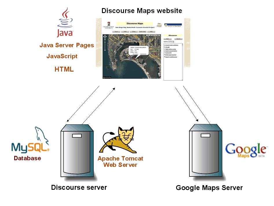
The design of the web-based Discourse Maps software includes three main components: The DisMap website, the Discourse Server and the Google Maps Server. The website is implemented using Java Server Pages (JSP). This technology enables the use of different programming languages in one website: HTML is used for the graphical components of the website while Java and JavaScript are chosen for implementing the functionalities. As the Google Maps Server offers a JavaScript Application Programming Interface (API) to request maps from the server, JavaScript is used especially to create this aspect of the website. The Discourse Server will host two main components: A MySQL database and an Apache Tomcat Web Server containing a Java Servlet. The servlet running on the Tomcat Web Server represents the communication interface to the database. The communication between the Website and this database servlet will be realized in the eXtensible Markup Language (XML). |
|