****JavaScript web menu drop down DHTML menu generated by NavStudio. (OpenCube Inc. - http://www.opencube.com)****
|
||||||||||||||||||||
THE SWEETWATER WATERSHED (HU 909.00)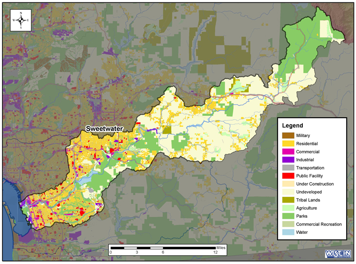
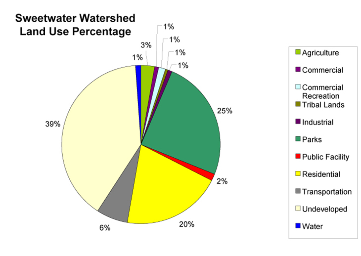
The Sweetwater watershed is the largest of the three watersheds that border San Diego Bay, encompassing over 148,000 acres. The watershed includes three hydrologic areas: Lower Sweetwater, Middle Sweetwater, and Upper Sweetwater . Major water bodies within the Sweetwater watershed include the Sweetwater River , Sweetwater Reservoir, Loveland Reservoir, and San Diego Bay . The Sweetwater River flows into San Diego Bay. The area of the River that is tidally influenced is known as the Sweetwater River Estuary, located on the border of National City and Chula Vista. The Estuary is a broad, straight, deep channel that forms the mouth of the Sweetwater River, which is the Estuary's primary source of fresh water. Tidal influence is somewhat restricted in the inner areas of the Estuary by bridge crossings at Interstate 5 and Broadway Street. The outer portion of the Estuary is surrounded by commercial and industrial lands uses to the north, whereas the southern side is bordered by the Sweetwater Marsh National Wildlife Refuge. Freeways bound both sides of the middle and inner Estuary north of Interstate 5. The majority of the watershed is in the jurisdiction of the County of San Diego, with smaller portions split between the City of Chula Vista, La Mesa, Lemon Grove, National City, the City of San Diego, and the San Diego Unified Port District. Most of the undeveloped land in the Sweetwater watershed is occupied by the Cleveland National Forest, Cuyamaca Rancho State Park, and the unincorporated communities of Pine Valley, Descanso, Alpine, and the Viejas Indian Reservation. Land use in the watershed is primarily Undeveloped (39.8%), Residential (20.2%), and parks and recreation (24.6%) (SANDAG 2003). Land ownership is mostly private with the remaining areas controlled by local, state, federal governments, and tribal lands. Population for the watershed is approximately 300,000 and is expected to grow 22% by the year 2015.
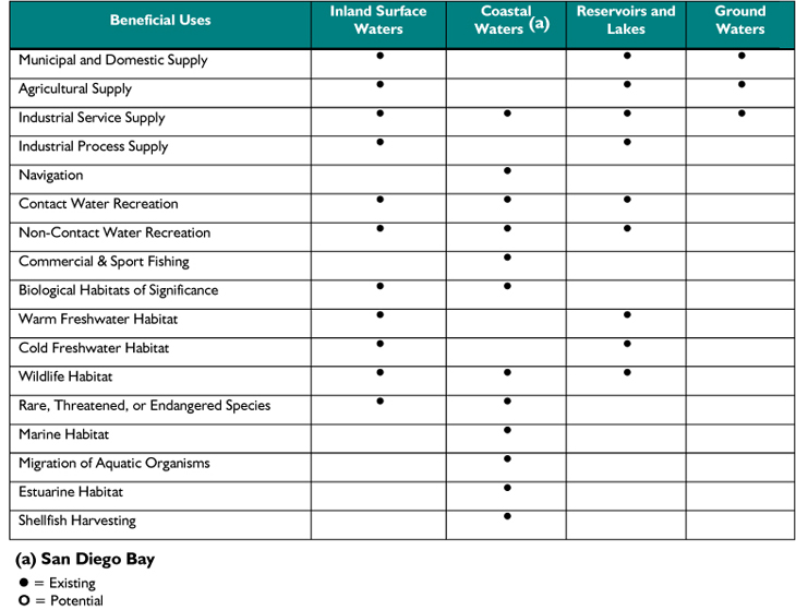
Rainfall in the watershed widely varies 10.5 inches near the coast to approximately 35 inches in the upper inland areas. TABLE 1: Beneficial uses within the Sweetwater Watershed
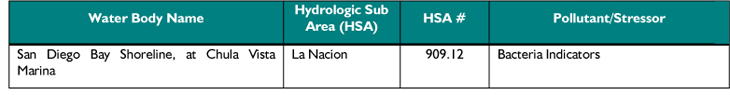
Source: Basin Plan September 8, 1994 (Tables 2-2, 2-3, 2-4, 2-5) TABLE 2: Water bodies on the SWRCB 303(d) list in the Sweetwater Watershed
|
||||||||||||||||||||
 The Sweetwater watershed provides many beneficial uses with its large areas of open space, state parks, national forests, rivers, reservoirs, and the shoreline of San Diego Bay (Table 3). Principal aquifers in the watershed include the Lower and Middle Sweetwater Basins and the San Diego Formation. Major impacts to the watershed include surface and groundwater quality degradation, habitat degradation, and invasive species. Constituents of concern include coliform bacteria, pesticides, and nutrients. Table 4 presents the water bodies that have been placed on the SWRCB 303(d) list.