The San Diego Bay Watersheds Common Grounds Project was created to incorporate data from water quality monitoring programs and integrate this data on a watershed level using a web-based interactive application to serve as a broad communication, education and decision-making tool; and to further develop the region's capacity to understand and assess processes affecting our water resources.

THE OTAY WATERSHED (HU 910.00)


Major Waterbodies Upper and Lower Otay Reservoirs, Otay River, San Diego Bay
CWA 303(d) List

Pacific Ocean (Coronado): coliform bacteria

Areas of Concern

Coliform bacteria, trace metals and other toxic constituents

Sources of Problems

Urban runoff, agricultural runoff, resource extraction, septic systems, marinas and boating activities

Human Population 150,000
Cities in Watershed

Chula Vista, Imperial Beach, Coronado, National City, and San Diego

Important hydrologic resources Upper and Lower Otay Lakes are two water supply reservoirs that also provide important habitat and recreational opportunities.
Major Issues/ Problems

Surface and groundwater quality degradation, habitat degradation and loss, and invasive species

Land Use

Land use in the watershed is primarily undeveloped (44%), parks and recreation (30.4%), and residential (9.99%). There is approximately 23.2% impervious surface.

Other Facts

1. The Otay River watershed encompasses approximately 160 square miles in southwest San Diego County and is one of the three watersheds that discharge to San Diego Bay.

2. Approximately 36 square miles of the watershed is part of the Multiple Species Conservation Plan (MSCP) effort that provides habitat for a wide range of endangered plant and animal species. Other important conservation areas within the watershed include the San Diego National Wildlife Refuge, the Rancho Jamul Ecological Reserve, and the vernal pool lands in the region.

3. The current population in the Otay River watershed is approximately 150,000 people. At the present time, serious water quality problems are limited to the presence of elevated coliform bacteria in the Pacific Ocean receiving waters near Coronado.

However, an expected population increase of 88% from 1998 – 2015 will substantially increase the volume of urban runoff in the watershed, and could significantly alter the present water quality status. In the absence of effective watershed-based management, the natural resources of the Otay River watershed may be significantly degraded.

(Information adapted from http://www.projectcleanwater.org)

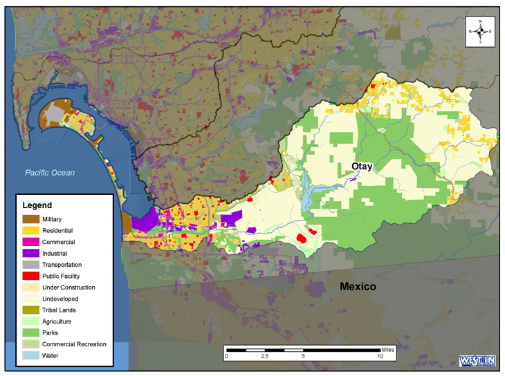
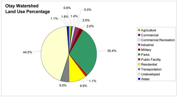
The Otay watershed comprises approximately 98,500 acres. It consists of three hydrologic areas: Coronado, Otay, and Dulzura. Major water bodies include the Upper and Lower Otay Reservoirs, Otay River, and San Diego Bay .

Nearly 70 percent of the watershed is unincorporated with the remaining portions divided between the Port of San Diego, Chula Vista, Coronado, Imperial Beach, National City, and San Diego.

Land ownership is predominantly private with a small percentage of local, state, and federally owned lands.

The Otay watershed is one of the least populated watersheds in the San Diego Region with approximately 143,000 people. That number is expected to increase by nearly 90 percent by the year 2015. Land use in the watershed is primarily vacant/undeveloped (44%), parks and recreation (30%), and residential (10%).

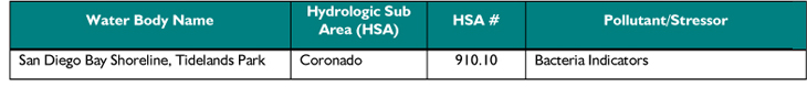
The Otay watershed provides many beneficial uses with conservation areas that include the San Diego National Wildlife Refuge, the Rancho Jamul Ecological Reserve, and approximately 23,000 acres that provide habitat for endangered plant and animal species as part of the Multiple Species Conservation Plan (Table 5). The two major reservoirs in the watershed supply water, important wildlife habitat, and recreational opportunities. The Lower Otay Reservoir lies at the end of the San Diego Aqueduct. The San Diego Formation is the principal aquifer in the watershed. Table 6 shows the water body that has been placed on the CWA 303(d) list. Annual rainfall varies from 8.25 inches at the coast to 19.5 inches in the inland areas. Most of the runoff from this watershed is collected at the Otay Reservoir. The reservoir only releases water during extremely large rain events and thus no flow was recorded during the 2001-2002 monitoring season; subsequently, this station was decommissioned after that season.

TABLE 1: Beneficial uses within the Otay Watershed

TABLE 2: Water bodies on the SWRCB 303(d) list in the Otay Watershed

BACK TO WATERSHEDS MAP


San Diego Bay Watersheds http://www.sdbay.sdsu.edu   | Sitemap    | Glossary