
****JavaScript web menu drop down DHTML menu generated by NavStudio. (OpenCube Inc. - http://www.opencube.com)****
|
|
The Hydrologic Cycle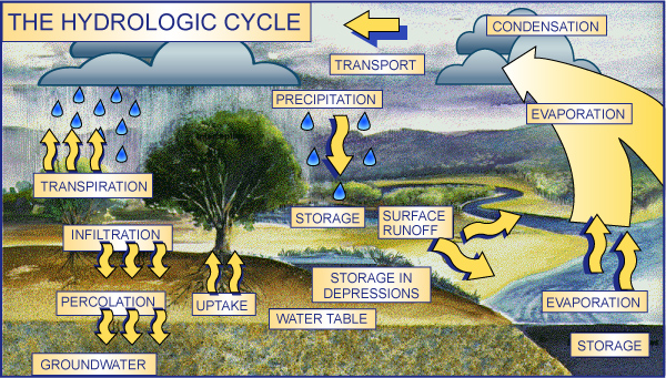
Hydrologic Animation Cycle
(Link to Earth Guide project at UC-San Diego) The HYDROLOGIC CYCLE begins with the evaporation of water from the surface of the ocean. As moist air is lifted, it cools and water vapor condenses to form clouds. Moisture is transported around the globe until it returns to the surface as precipitation. Once the water reaches the ground, one of two processes may occur; 1) some of the water may evaporate back into the atmosphere or 2) the water may penetrate the surface and become groundwater. Groundwater either seeps its way to into the oceans, rivers, and streams, or is released back into the atmosphere through transpiration. The balance of water that remains on the earth's surface is runoff, which empties into lakes, rivers and streams and is carried back to the oceans, where the cycle begins again. The portion of water which does not infiltrate the soil but flows over the surface of the ground to a stream channel is called surface runoff. Water always takes the path of least resistance, flowing downhill from higher to lower elevations, eventually reaching a river or its tributaries. All of the land which eventually drains to a common lake or river is considered to be in the same watershed. Watersheds are defined by topographic divides which separate surface flow between two water systems. Land use activities in a watershed can affect the water quality of surface water as contaminants are carried by runoff and of groundwater, especially through infiltration of pollutants. Understanding the factors which influence the rate and direction of surface water and groundwater flow helps to determine where good water supplies exist and how contaminants migrate. Now that you have learned about the Hydrologic Cycle,Click here to follow the path of a water droplet through our Watershed. |
|